CFS Deployment to New South Wales. 2013
Contributed Photo Galleries -18th to 27th October 2013
back to deployment galleryphoto@fire-brigade.asn.au
This page was created on the 29th October 2013 and updated on the 16th November 2013. This gallery of pictures contains images taken by CFS Volunteers, Community Members and other Emergency Service personnel during the fires New South Wales between the 18th and 27th of October 2013. More pictures will be added to this gallery as they are received
Whilst every effort has been taken to acknowledge the relevant photographer, we understand some may not be correct. If any of these pictures are yours and not correctly acknowledged, please let us know.
Details of each fire can be found below the picture gallery - Click Here
Matt Bonser, Morphett Vale CFS
Dave Fitch, Bradbury CFS
Jack Gloyn, Eden Hills CFS
Iain Hepburn, Dalkeith CFS
Lucas Hobbs, Mylor CFS
Gavin Hodgson, Crystal Brook CFS
Peter Inkster, CFS Region 2 Operations
Robbie Kay, Murray Bridge CFS
Jason Kleinig, Tatiara CFS Group
Lincoln CFS
Tim Maitland, SAMFS & Cherryville CFS
Mel Mazzone, Stirling CFS
Kirstie McGarrity, Morgan CFS
Terri Minge, Chaffey CFS Group Operations Support
Morphett Vale CFS
NSW Police
Glen Roberts, One Tree Hill CFS
Michael Roberts, Happy Valley CFS
Lauren Wait, Port Lincoln CFS
Jiron Blacket, Murray Bridge CFS


Matt Bonser, Morphett Vale CFS
 |
| mb-penrith241013-.jpg |
Dave Fitch, Bradbury CFS
 |
 |
 |
 |
| df-bellslineofrd-251013-.jpg | df-bellslineofrd-251013-1.jpg | df-penrtih231013.jpg | df-yarramundi-.jpg |
Jack Gloyn, Eden Hills CFS
 |
 |
 |
 |
 |
 |
| jg-backburn-bluemtnp-201013-2.jpg | jg-backburnbluemtnp-201013.jpg | jg-backburnbluemtnp201013.jpg | jg-backburnbluemtnp201013-1.jpg | jg-backburnspringwood191013-jpg.jpg | jg-viewbluemt-211013-.jpg |
Iain Hepburn, Dalkeith CFS
 |
| ih-bluemountains-.jpg |
Lucas Hobbs, Mylor CFS


Gavin Hodgson, Crystal Brook CFS
 |
 |
| gh-2nd-deployment.jpg | gh-bellslineofrd-.jpg |
Peter Inkster, CFS Region 2 Operations


Robbie Kay, Murray Bridge CFS
 |
| rk-outofsydney-.jpg |
Jason Kleinig, Tatiara CFS Group


.jpg)


.jpg)


Lincoln CFS
 |
| lincolncfsblackout-231013-.jpg |
Tim Maitland, SAMFS & Cherryville CFS


Mel Mazzone, Stirling CFS
 |
| mm-convoy-.jpg |
Kirstie McGarrity, Morgan CFS
 |
 |
| km-231013.jpg | km-241013-.jpg |
Terri Minge, Chaffey CFS Group Operations Support
 |
 |
 |
 |
 |
 |
| tm-261013.jpg | tm-261013-2jpg.jpg | tm-jugiong-.jpg | tmi-27-10-13.jpg | tmi-chaffeybw7-.jpg | tmi-narranderra-261013-.jpg |
Morphett Vale CFS


NSW Police
 |
 |
| bluemountainsLAC-.jpg | nswpolice-hume-.jpg |
Glen Roberts, One Tree Hill CFS
 |
 |
| gr-cfsomrfsappliance-Gxz2Ir1.jpg | gr-springwood-.jpg |
Michael Roberts, Happy Valley CFS
 |
 |
| mr-sydney-stagingSA-.jpg | mr-sydney-staginhg.jpg |
Lauren Wait, Port Lincoln CFS
 |
 |
 |
 |
 |
 |
| 187.jpg | 190.jpg | 193.jpg | 194.jpg | 204.jpg | 208.jpg |
 |
 |
 |
 |
 |
 |
| 209.jpg | 211.jpg | 212.jpg | 213.jpg | 214.jpg | 215.jpg |
 |
 |
 |
 |
 |
 |
| 216.jpg | 217.jpg | 218.jpg | 227.jpg | 231.jpg | 232.jpg |
 |
 |
 |
 |
 |
 |
| 233.jpg | 239.jpg | 240.jpg | 242.jpg | 245.jpg | 246.jpg |
Linksview Road, Springwood (Blue Mountains)
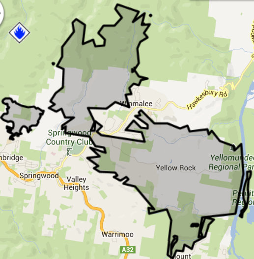
LOCATION: North of Great Western Highway, east of Hawkesbury Rd; south to Winmalee Ridge, west of the Nepean River, east of Chapman Rd Springwood. 1.5km North of Tom Hunter Park and Springwood Golf Club
COUNCIL AREA: Blue Mountains
STATUS: Under Control
TYPE: Bush fire
SIZE: 3623 ha
Current Situation The Linksview Road Fire started on Thursday 17 October 2013 and has burnt 3,623ha.
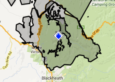
Mt York Road, Mt Victoria Bush fire (Blue Mountains.
LOCATION: Located at Mt York Rd, Mt Victoria, Darling Causeway, Bells Line of Road, Blackheath, Mt Banks 3km north of Mt Boyce 4km north of Blackheath 2km east of Little Hartley 3km south of Hartley Vale
COUNCIL AREA: Blue Mountains
STATUS: Under Control
TYPE: Bush/Scrub fire
SIZE: 8476 ha
Current Situation After starting on the 17th October, firefighters were able to contain this fire at 10:30 am 28th October after it burnt out motre than 8,000 hectares of bush land.
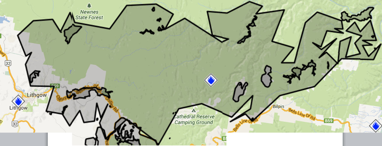
State Mine Fire (Lithgow and Blue Mountains Local Government areas)
LOCATION: Between Lithgow And Bilpin to the north of Bells Line of Road
COUNCIL AREA: Lithgow
STATUS: Under Control
TYPE: Bush/Scrub fire
SIZE: 55182 ha
Current Situation The State Mine Fire started on Wednesday 16 October 2013 near Lithgow and burnt 52,813ha